Jakarta looks greener on the map than in reality
Green open spaces (GOS) in cities play a significant role in providing space to catch one’s breath in hyper-dense metropolitan areas. GOS, or what we could simply call greenery, should be a staple feature of cities in order to fulfill people’s needs. But eventually, what if your greenery could be replaced by a cemetery? Well, it would still be green on the surface, though. The real question is: would you like to spend your leisure time in a cemetery? Probably not. If you would, you might be interested in urban legends or something similar.
Well, back to the real issue, where legal instruments are responsible for defining greenery and translating it into actionable practices, while allowing this loose definition to persist. In this blog, I would like to bring you into a discussion about how greenery is not really an important provision, or is perhaps nearly unimportant, in Indonesia’s legal framework, especially where it overlaps with the spatial domain.
This blog is based on a paper I co-authored with Jarot Mulyo Semedi, published in Human Geography: Indonesia’s urban green spaces dilemma: Balancing law, ecology, and public space, highlighting Jakarta. If you want a copy of the paper, just email me!
“Space” as more than just measurable land
The fact is that Indonesia’s spatial legal framework still keeps an eye on greenery provision as an environmental savior and a public need, mandating that 30% of a city’s land must be provided for greenery1. Imagine that one-third of the city area might have been greenery. But apparently, this mandate is not something that every city must fulfill the next day. It is more like a set of goals without any deadline attached to it.
The mandate leaves one important caveat. It does not differentiate what people need from what spatial governance is trying to achieve. Consequently, every city can have its own measurement by enabling cemeteries, planted road medians, etc. to be counted as greenery. On the surface, that is a creative interpretation, to be fair.
Jakarta as a good (and bad at the same time) example
Jakarta has actually done a pretty good job providing GOS across its jurisdiction. Spatially, GOS appears evenly spread if you look at it from above. It has been published by the Jakarta Government itself2 in the form of a WebGIS (you’d better check it out first!). The numbers are not superior, but the effort should be praised.
I just wonder how Jakarta was able to provide all those greeneries alongside a hyper-dense metropolitan environment. And yes, that’s how I praise Jakarta in this regard. Nothing else. One thing we can blame is that Jakarta deliberately includes cemeteries, road medians, etc., which have nothing to do with park-like greenery. Like I said earlier, a cemetery can’t be included as public space in the literal meaning. The same goes for road medians: they are green on the surface but technically, and obviously, unreachable. Who is going to put a bench in the middle of a two-lane road? No one.
What I’m trying to say here is that the green itself is not merely a surface; it needs to be defined together with the other two words, “open” and “space”.
So… what is Green Open Space (“Green”, “Open”, and “Space”) really?
Discussing a definition could be perceived as a trivial stage. In some way, it could be a double-edged sword. Peeling the words apart one by one just takes time and patience, and it feels like nitpicking until you notice that the whole problem lives inside a single sentence of the law.
Here is that sentence, roughly translated: GOS is an elongated or clustered area used as a place for plants to grow, whether naturally or intentionally planted1. Read it again. Are there plants growing? Green. Planted on purpose or not? Still green. Shaped like a strip? That is fine too. Nothing in there asks who can walk in, what the plants do for the city, or whether anyone would want to sit there. A median passes this test. So does a cemetery. So, to be fair, does a private garden behind a gate.
Take the words one at a time. “Green” only means plants are present. Whether the soil takes in rainwater or the shade actually cools a street is not part of the test. “Open” is where the law splits GOS into 20% public and 10% private, which looks neat and fair on paper. But the private 10% is easily met by gardens inside elite housing complexes, while the public 20% is the part Jakarta cannot find land for. “Space” is the sneakiest. In Indonesian spatial law, ruang is supposed to work as a wadah, a container of social and ecological processes. Then the word “elongated” arrives and the container becomes a line on a map.
Later regulations did not fix this. They stretched it. The 2008 Ministry of Public Works regulation3 divided GOS functions into intrinsic (ecological) and extrinsic (social, cultural, economic), which sounds like ecology comes first. In practice, plazas, sports fields, cemeteries, road buffers, and medians could all count toward the target. The 2022 ministerial regulation4 went further. It brought in the Indonesia Green-Blue Index and recognized “Non-GOS”, meaning hardened areas paved with “eco-friendly” materials, as well as vertical greenery and porous pavements, as countable components. Yes, pavement can now help a city hit its green target. I would love to see someone explain that to a tree.
This is where a little theory helps. I promise it is short.
Henri Lefebvre5 separated space into three kinds. Conceived space is the space of planners and lawmakers: abstract, technical, full of ratios. Perceived space is the material city, what is physically there. Lived space is how residents experience and use the city every day. The 30% mandate is conceived space in its purest form. It tells us what space should be, and says very little about what space does.
David Harvey6 adds the justice question: the issue is not only how much green space exists, but who controls it, who can access it, and who is responsible for providing it. Remember the WebGIS map that looked evenly spread? From the ground, the picture changes. North and Central Jakarta, home to dense working-class settlements, have the least greenery, while the South, with its private gardens and gated communities, adds a lot to the “green” statistics. Jane Jacobs7 would probably roll her eyes at the rest: ornamental lawns and fenced medians are made to be seen, not lived in.
Which part is actually entangled?
Official data puts Jakarta’s green coverage at around 5.5%2. The target is 30%. Nobody in this story is happy with that gap, so why does it stay? Because three actors are stuck in the same space, and each of them lives in a different version of it.
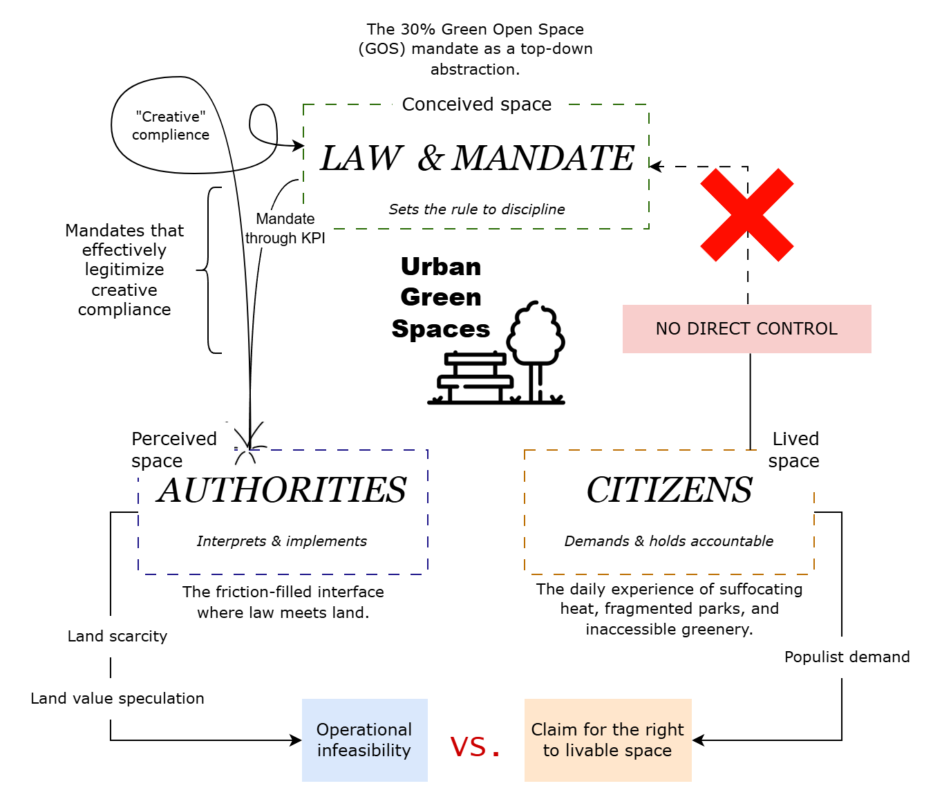
Law, authorities, and citizens: three actors, one space, and no one able to move.
Law and mandate sit at the top, as conceived space. The 30% is a top-down abstraction, and it reaches the city through a KPI. A KPI wants a number. It does not ask how the number was made.
Authorities sit in the middle, as perceived space. This is the friction-filled interface where law meets land, and the land is the problem. Land is scarce, and land value is speculative. When a plot is worth that much, giving 30% of the city to plants is operationally infeasible. So they do what the KPI allows: creative compliance. Road buffers, riverbanks, and cemetery grounds are recoded as GOS polygons, and scattered fragments become a statistical achievement. Look at the loop in the figure. The mandate effectively legitimizes the very shortcut that was invented to get around it.
Citizens sit on the other side, as lived space. They are the ones who feel the result: suffocating heat, fragmented parks, and greenery they cannot enter. Their demand is populist, and I mean that without any insult. It is a claim for the right to livable space. But look at the red cross in the figure. Citizens have no direct control over the law. All they can do is press the authorities, who are already stuck.
So it ends up as operational infeasibility versus the claim for the right to livable space. I would not call this simple laziness on either side. The paper calls it a structural impossibility, and that fits better. The result is a kind of performative governance. A new plaza gets inaugurated, paved and ornamental, and everyone goes home satisfied. Citizens see green, the state sees compliance, and the ecology has no seat at the table.
So, what now?
The paper does not say to throw the 30% away. As a KPI, it still has its uses. What has to change is the question we ask. Instead of “how much green space does Jakarta have?”, ask “how many residents are actually covered by it?” A city can pass its KPI in total and still leave its densest kampungs with nothing, and in a kampung, a green space that is distant, fragmented, or fenced is, in practical terms, absent. A simple check would be whether people can reach green space within a 5 to 10 minute walk (around 300 to 500 m) from where they live.
Yes, that sounds populist. It is meant to. GOS is a populist spatial provision, something the state is expected to deliver and residents experience directly in their daily lives.
The second fix is about what gets counted. Right now there is no clear baseline for what qualifies as GOS, so almost anything does. The paper proposes a weighted functional ratio, which scores a site on its ecological performance and its social function. For illustration, take a 60:40 ratio between the ecological and the social. A fully accessible, vegetated park gets close to full credit, while a fenced strip or an ornamental median gets partial credit. The numbers are not fixed. The point is that a minimum standard exists, so that reported provision looks more like what people can actually use.
Under a system like that, the cemetery would still get some credit. Just not a full one, and I can live with that.
Jakarta looks greener on the map than in reality. The goal is simply for the two to stop disagreeing. Or, as the paper puts it, to care for space is not to count it but to inhabit it.
-
Government of the Republic of Indonesia (2007) Law of the Republic of Indonesia No. 26 of 2007 on Spatial Planning. Available at: LINK ↩ ↩2
-
DKI Jakarta Provincial Government (2026) Green Open Space Information in DKI Jakarta Province. Available at: LINK. ↩ ↩2
-
Ministry of Public Works of the Republic of Indonesia (2008) Regulation of the Minister of Public Works No. 05/PRT/M/2008 on Guidelines for the Provision and Utilization of Green Open Space in Urban Areas. ↩
-
Ministry of Agrarian Affairs and Spatial Planning/National Land Agency of the Republic of Indonesia (2022) Regulation of the Minister of Agrarian Affairs and Spatial Planning/Head of the National Land Agency of the Republic of Indonesia No. 14 of 2022 on the Provision and Utilization of Green Open Space. ↩
-
Lefebvre, H. (1991) The Production of Space. Oxford, UK & Cambridge, USA: Blackwell. ↩
-
Harvey, D. (1973) Social Justice and the City. Athens, GA: University of Georgia Press. Available at: LINK. ↩
-
Jacobs, J. (1961) The Death and Life of Great American Cities. New York: Random House. ↩